RESOURCES
- Northwest Passages:History of the Seattle District U.S. Army Corps of Engineers Volume II 1920-1970 (pdf 29.2mb)
- HistoryLink.org essay on the Lake Washington Ship Canal
Links to external websites do not constitute endorsement by WSDOT of the linked websites or the opinions, information, products or services contained therein.
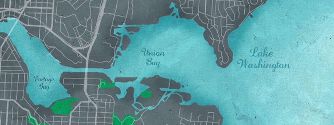
In the 1910s, the large-scale transformation of the Montlake Portage into a transportation corridor accelerated. Construction of a ship canal across the portage began in 1909 when the Army Corps of Engineers awarded excavation contracts for the Lake Washington Ship Canal. The federal canal project included channel dredging, canal construction at Montlake and in Fremont, and locks at Ballard to connect Lake Washington with Puget Sound.
To address the different levels between Lake Washington, Lake Union, and Salmon Bay, the government built a double lock at Ballard and lowered Lake Washington about nine feet, to the same height as Lake Union. The level of Salmon Bay was raised to 21 feet behind the locks and dam at its mouth. The lowering of Lake Washington and raising of Salmon Bay caused a number of changes to the watershed, the most dramatic of which was the drying up of the Black River when the level of Lake Washington dropped below the river channel entrance. As a result, the way water moved through the watershed changed drastically, with environmental and human consequences.
The canal created an obstacle to vehicles traveling between the east side of central Seattle and northeast Seattle neighborhoods. The closest bridge crossed the ship canal at the eastern side of Portage Bay, about one and one-half miles away by land. After years of conflict over funding and a dispute over the bridge design, the Montlake Bridge finally opened in 1925, allowing easier access to neighborhoods like Laurelhurst and Sand Point.
Toward the middle part of the century, the region experienced many other changes, which had a lasting influence on transportation and land use. The Lacey V. Murrow (I-90) Bridge across Lake Washington opened in 1940 to great fanfare. But one floating bridge across Lake Washington could not support the demand of the booming population on the Eastside. Beginning in 1946, citizens in Seattle and the Eastside began calling for a second floating bridge, resulting in the Governor Albert D. Rosellini/Evergreen Point Bridge (SR 520). At the end of its construction in 1963, the Evergreen Point Bridge became the longest floating concrete bridge in the world. Measuring 1.4 miles from the Montlake area of Seattle across Lake Washington to Medina, the bridge formed the center portion of the 5.8-mile project that connected the two main north-south highways in the greater Seattle area, Interstate 5 and Interstate 405 on the east side of Lake Washington. The Evergreen Point Bridge was built as a four-lane toll bridge, to provide easy access to and from Seattle for the growing Eastside communities, such as Bellevue, Kirkland, and Redmond. The opening of the Evergreen Point Bridge stimulated development in the communities on the Eastside. The areas grew substantially in the decades following construction of the bridge, eventually increasing traffic and resulting in a more difficult commute across Lake Washington.
Visit HistoryLink.org to read more about the changing landscape.