RESOURCES
- Geomorphological Research Group
- The Burke Museum
- HistoryLink.org essay on glaciation of the Puget Sound region
Links to external websites do not constitute endorsement by WSDOT of the linked websites or the opinions, information, products or services contained therein.

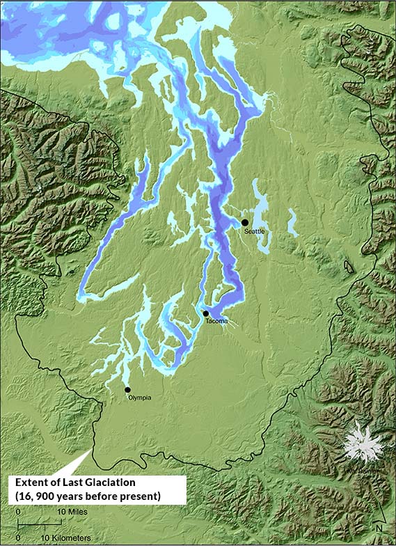
Seattle and the Puget Sound region have been shaped by glaciers, geothermal events, and erosion. A product of the ice age, the region has been covered by glaciers many times over. At its peak, the ice extended south to present-day Olympia, covering the entire region beneath 3,000 feet of ice. When the last glacier began retreating some 17,000 years ago, it formed a massive freshwater lake that was about 120 feet higher than today’s sea level. This lake quickly drained when the glacier melted north of the Strait of Juan de Fuca, opening Puget Sound to the saltwater of the Pacific. The isthmus between the lakes that would come to be known as Union and Washington offered one of the few surmountable passages between Puget Sound and the inland areas. The natural forces - including glaciation, geothermal events, and erosion - that shaped the landscape over time are described here.
The Vashon stade was the last glacial advance and retreat to cover the region. It was the last of at least seven glaciations during the Pleistocene Epoch, which lasted from two million years b.p. (before present) to about 10,000 years b.p. Extending as far south as the Olympia area to the west and the Spokane area to the east, the ice sheet, at its thickest, reached 3,000 feet. To give a comparison, the Pacific Northwest's tallest skyscraper (as of 2013), Seattle's Columbia Center, is about 997 feet tall.
On the west side of the Cascade Mountains, two glacial lobes covered the Puget Lowlands, depositing hundreds of feet of Lawton Clay, Esperance Sand, and Vashon Till. Meltwater flowing below the ice carved out the valleys we know today. Many of the area's water bodies fill these troughs, including Puget Sound, Lake Washington, Lake Union, Lake Tapps, and Lake Sammamish. Some of the meltwater moved across in the direction of the ice flow, creating east-west oriented valleys like the cleft through which the present-day Lake Washington Ship Canal runs. The receding ice left glacial debris (moraines) at its margins, outwash deposits left by meltwater streams, and exposed ridges left by glaciers (drumlins) that largely run parallel to each other.
The ice sheet exerted enormous pressure, pushing the land down, but over time the land rebounded, slowly raising the elevation of the valley floors. In the White-Green-Duwamish valley, the massive deposition of mud and rock by the Osceola Mudflow about 5,600 years accelerated this process.
The level of Lake Washington slowly rose about 40 feet as the Cedar River alluvial fan at its mouth built up over time. A narrow strip of land eventually formed the only division between Lakes Union and Washington. Native communities took advantage of the low-lying land between the hills to cross between the lakes as they traveled via canoe around the region.
For more information about how the Vashon stade shaped Washington's landscape, visit HistoryLink.org.